DRONE® CoE
DRONE® CoE
Key Activities
● Open Designs on UAVs
● Drone based Aerial mapping
● OpenStreetMap Contributions
● Emerging Technology Awareness Programmes
● Technology Consulting
CoE Milestones
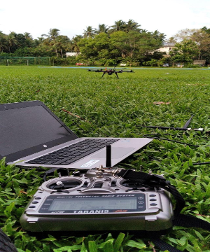
● Designed and Developed Hexacopter Drone using Free software
and hardware
● Drone based Land Use mapping at Niranam Grama Panchayath
● Structural Mapping of GreenField Stadium
● Mapping Canal System within Thrissur Kole Wetlands
● Corridor Mapping at Kariavattom-Thrippadapuram Road
● 3D modelling and mapping at Karakulam Grama Panchayath


Images from top left to right: opensource hexacopter, Example of
3D structural mapping greenfield stadium, RC Flying wing, hexacopter
developed for mapping purpose,RC Fixed wing airplane, Design View
(flying wing).