MULTICROP AGRICULTURAL FIELD MAPPING
GIS Mapping & Drone Technology
GIS Data visualisation and analysis
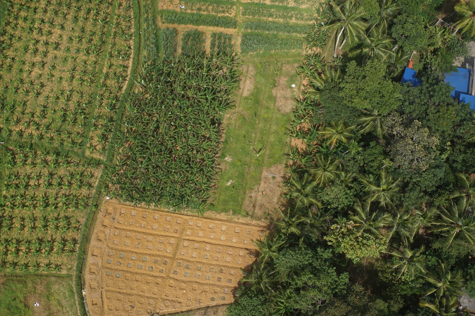
This project aimed to harness the full potential for elevating agricultural practices. Our primary objectives were to assess the capabilities of Unmanned Aerial Vehicles (UAVs) equipped with RGB (Red, Green, Blue) imaging systems in mapping agricultural fields. Additionally, we aimed to utilize the WebODM platform to generate precise orthophotos and employ the formidable QGIS software to create accurate maps of parcel boundaries for agricultural land. These advances enable us to predict crop yields with remarkable accuracy.
- tags: Gis&DroneMapping
- Share This
Project Updates
Related Projects
Automate & Simplify The Whole Process

GIS Data visualisation and analysis
<p>The present scenario of 3D modelling at high resolution is that the data sets or its applications are not open to the public and is highly commercialized. Although private organizations in India and abroad focuses on image based and range based techniques using drone technology for various applications like urban planning, hazard studies,hydrology etc, the use of such technologies in our state is limited. ICFOSS’s interest in Drone started with OpenDroneMap project which use photogrammetry techniques to generate orthophoto and DEM. We organized a 3-day workshop on Drone Mapping with the leadership of Mr. Stephen Mather, GIS Manager, Cleveland Metroparks, US and Mr. Frederick Mbuya, Managing Director Uhuru Labs & Consultant -World Bank; The workshop was handled by which covered drone technologies and photo reconstruction for aerial mapping.These products and 3D models can be used for meaningful spatial analysis such as surveying, monitoring, damage assessment, etc.<br></p>
Read more
Viewshed Analysis-Air Quality Monitoring in Thiruvananthapuram City
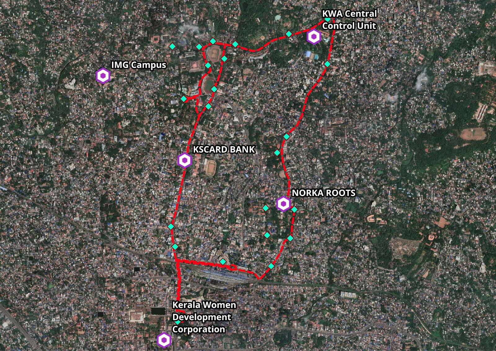
<p><span id="docs-internal-guid-2f2ff8c2-7fff-4cd2-9b19-fff681e675b7"><span style="font-size: 14pt; font-family: "Times New Roman", serif; background-color: transparent; font-variant-numeric: normal; font-variant-east-asian: normal; font-variant-alternates: normal; vertical-align: baseline; white-space-collapse: preserve;">The objective of the air quality monitoring project in Thiruvananthapuram City was to assess and improve air quality by deploying sensors on KSRTC buses. The project involved several crucial activities, including the preparation of a bus route map, identification of gateway locations using DEM analysis in QGIS software, and conducting viewshed analysis for these gateway locations. This overview provides a summary of these activities and their significance in the context of air quality analysis.</span></span><br></p>
Read more
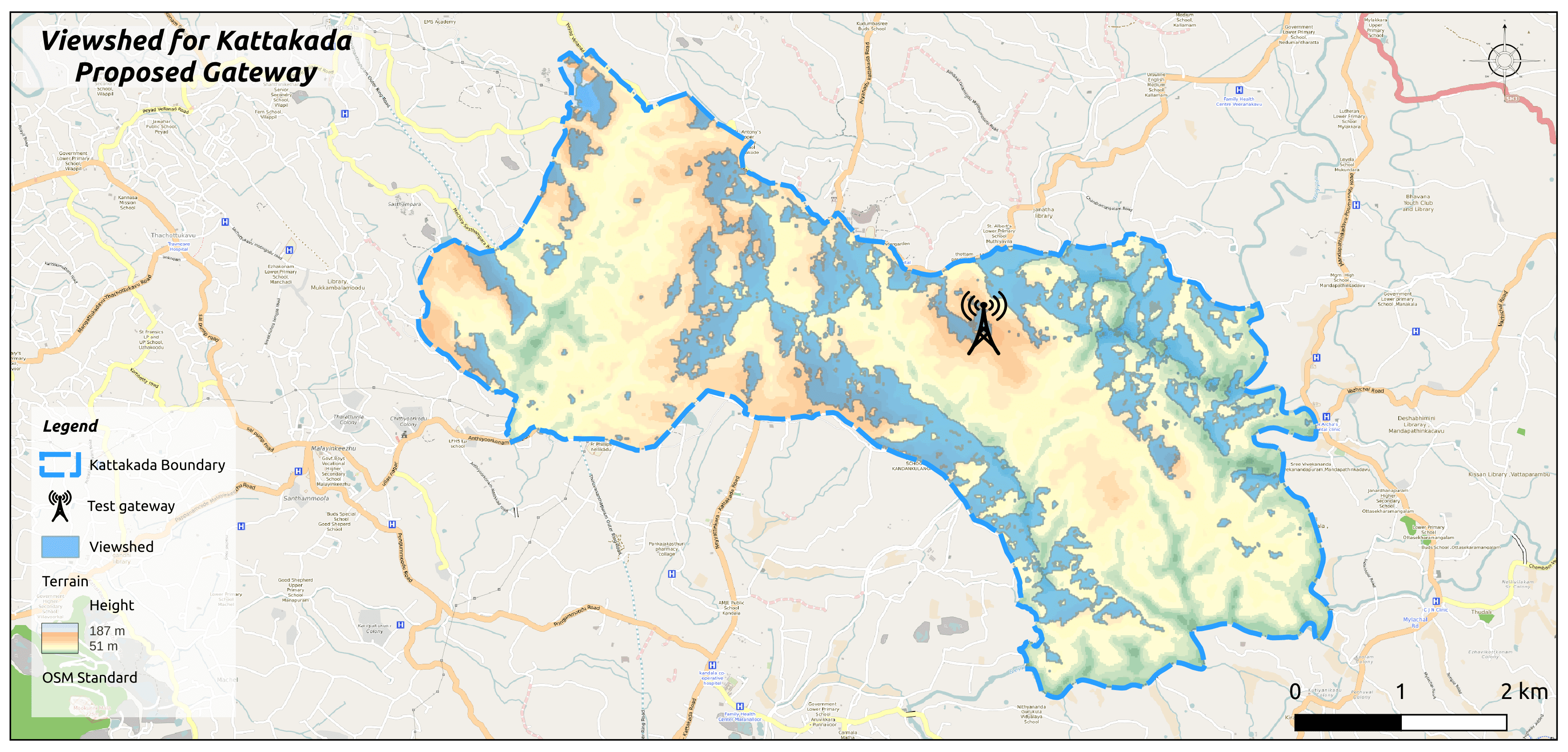
VIEWSHED ANALYSIS FOR LORAWAN GATEWAY PLACING AND NETWORK ESTABLISHMENT
<p>In a bid to revolutionise connectivity solutions, ICFOSS has harnessed the power of Viewshed Analysis in our projects. This spatial analysis technique, employed within the framework of Geographic Information Systems (GIS), holds the potential to redefine how we perceive and utilise landscapes in a multitude of sectors, from urban planning to environmental assessment.</p><p>Viewshed analysis entails a systematic process:</p><p>1. Data Collection: The cornerstone of this analysis lies in obtaining accurate elevation data, typically sourced from Digital Elevation Models (DEMs) derived from satellite or aerial imagery. These pivotal datasets were secured from reputable sources such as ASF Alaska.</p><p>2. Vantage Points: The selection of observer points, representing the desired gateway locations, forms the next crucial step. These vantage points, strategically positioned as gateways, encompass estimated antenna heights, serving as pivotal nodes in network establishment.</p><p>3. Visibility Calculation: Through sophisticated GIS software, in this case, the open-source QGIS, the system calculates areas visible from each observer point. By delineating lines of sight in all directions, obstructed regions due to elevated terrain or other impediments are marked as non-visible.</p><p>4. Visualisation and Interpretation: The resultant viewshed map offers a vivid representation of visible and concealed areas from observer points. This invaluable information guides decision-making processes, aiding in the optimal siting of sensors, assessing the influence of new developments, and identifying potential relay points.</p><p>Furthermore, this analysis can be extended to encompass multiple observer points simultaneously, an indispensable feature when considering visibility from a multitude of viewpoints.</p><p>ICFOSS emphasises the importance of utilising the QGIS platform, reinforcing that the precision of results hinges on factors such as elevation data quality, analysis resolution, and considerations for atmospheric conditions, vegetation, and other obstructions.</p><p>ICFOSS is proud to showcase the transformative power of Viewshed Analysis through two pioneering projects - Water Level Monitoring for CET and Barton Hill, as well as the IoT-enabled Panchayat initiative. By strategically leveraging this spatial analysis technique, ICFOSS is setting new benchmarks in connectivity solutions, revolutionising urban planning, environmental assessment, and a myriad of other sectors.</p>
Read more