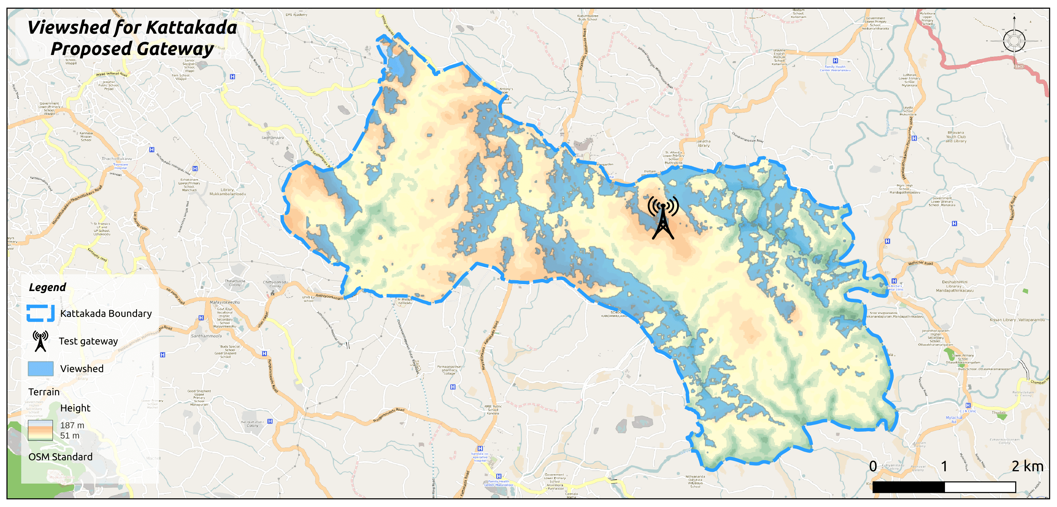
<p>In a bid to revolutionise connectivity solutions, ICFOSS has harnessed the power of Viewshed Analysis in our projects. This spatial analysis technique, employed within the framework of Geographic Information Systems (GIS), holds the potential to redefine how we perceive and utilise landscapes in a multitude of sectors, from urban planning to environmental assessment.</p><p>Viewshed analysis entails a systematic process:</p><p>1. Data Collection: The cornerstone of this analysis lies in obtaining accurate elevation data, typically sourced from Digital Elevation Models (DEMs) derived from satellite or aerial imagery. These pivotal datasets were secured from reputable sources such as ASF Alaska.</p><p>2. Vantage Points: The selection of observer points, representing the desired gateway locations, forms the next crucial step. These vantage points, strategically positioned as gateways, encompass estimated antenna heights, serving as pivotal nodes in network establishment.</p><p>3. Visibility Calculation: Through sophisticated GIS software, in this case, the open-source QGIS, the system calculates areas visible from each observer point. By delineating lines of sight in all directions, obstructed regions due to elevated terrain or other impediments are marked as non-visible.</p><p>4. Visualisation and Interpretation: The resultant viewshed map offers a vivid representation of visible and concealed areas from observer points. This invaluable information guides decision-making processes, aiding in the optimal siting of sensors, assessing the influence of new developments, and identifying potential relay points.</p><p>Furthermore, this analysis can be extended to encompass multiple observer points simultaneously, an indispensable feature when considering visibility from a multitude of viewpoints.</p><p>ICFOSS emphasises the importance of utilising the QGIS platform, reinforcing that the precision of results hinges on factors such as elevation data quality, analysis resolution, and considerations for atmospheric conditions, vegetation, and other obstructions.</p><p>ICFOSS is proud to showcase the transformative power of Viewshed Analysis through two pioneering projects - Water Level Monitoring for CET and Barton Hill, as well as the IoT-enabled Panchayat initiative. By strategically leveraging this spatial analysis technique, ICFOSS is setting new benchmarks in connectivity solutions, revolutionising urban planning, environmental assessment, and a myriad of other sectors.</p>
Read more